If the Lossenham Project has an ethos it’s about making the most of the estate in all its aspects. Our artist-in-residence Russell Burden takes care to scoop up every element Lossenham has to offer to mould into art of great beauty. He’s previously recorded sounds around the estate, from the crackling of logs on a bonfire, to wind through the trees and the song of the night birds. These he meshed with instruments, voices and electronic loops. The meditative album that emerged, Lossenham Frequencies, is shot through with the sheer presence of the place. And a very fine listen to boot.
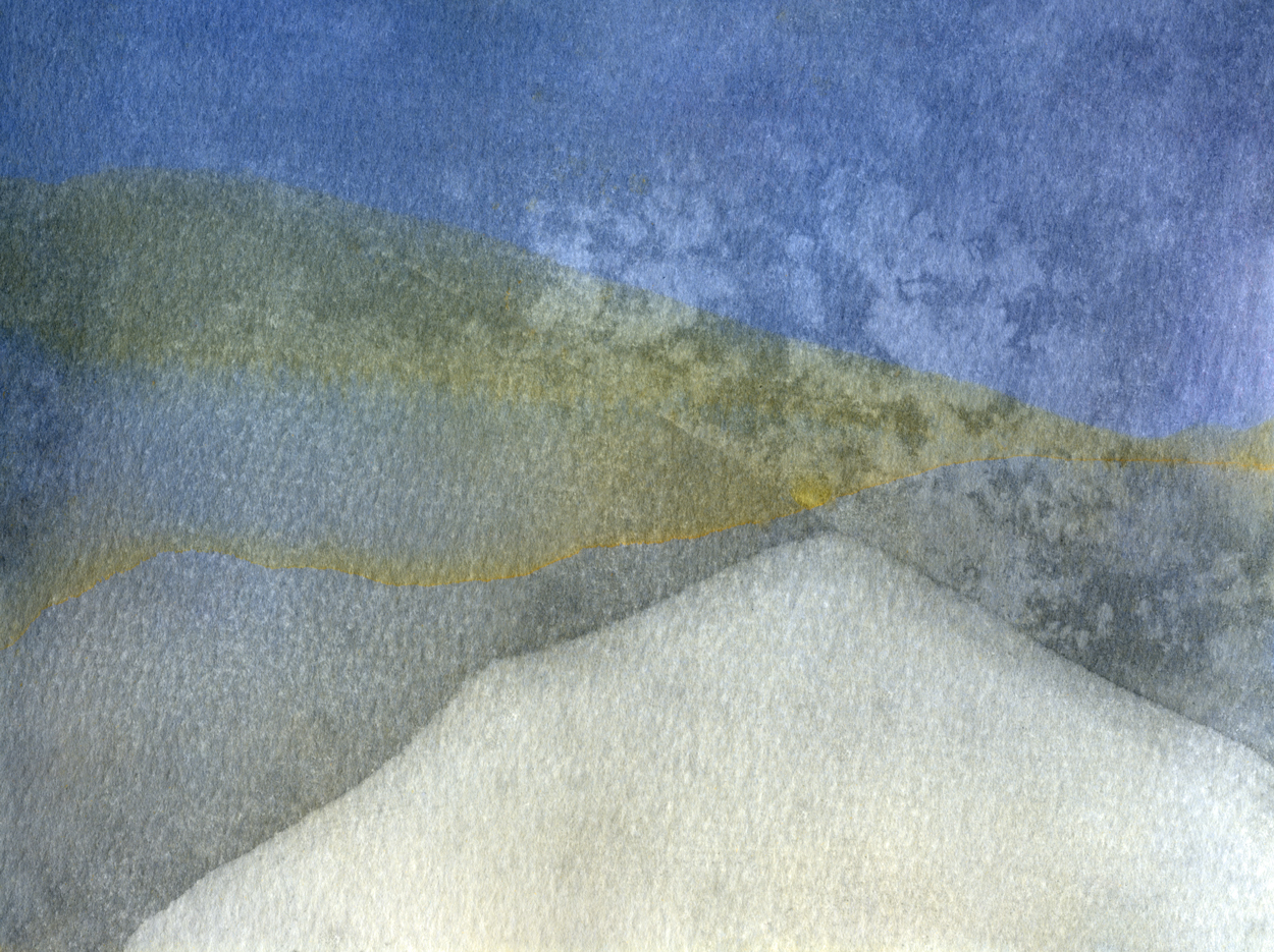
His latest work centres on cameraless image-making at its rawest, using two print techniques: lumen and cyanotype. In the first photographic paper is immersed in Lossenham’s ponds. Seeds floating on the surface and ivy pond weed take on an ethereal, three-dimensional quality when seen from underneath.
The second technique, cyanotype, involves watercolour paper treated with compounds of iron that react to water, light and the naturally occurring iron that abounds in the Wealden landscape.
“The joy is in the surprise,” Russell says. Sometimes the environment yields images both reminiscent of the hills of Mount Carmel and the local wetland map. The pictures serve as a reminder of the monks who once lived harsh, hermit lives in Palestine under the Rule of St Albert. They found refuge in a new priory at Lossenham, as they retreated from the Muslim re-conquest.
Next on Russell’s packed agenda is reviving the pottery project that he and Philip Warren began last year. They’ve proved that Lossenham’s clay performs well in kilns fashioned from the very same material. They’re looking for enthusiasts to help with the next phase of making ceramics, both practical and artistic. To register an interest contact: russell@lossenham.org.uk
Making places, making lives: Landscape and settlement in coastal wetlands
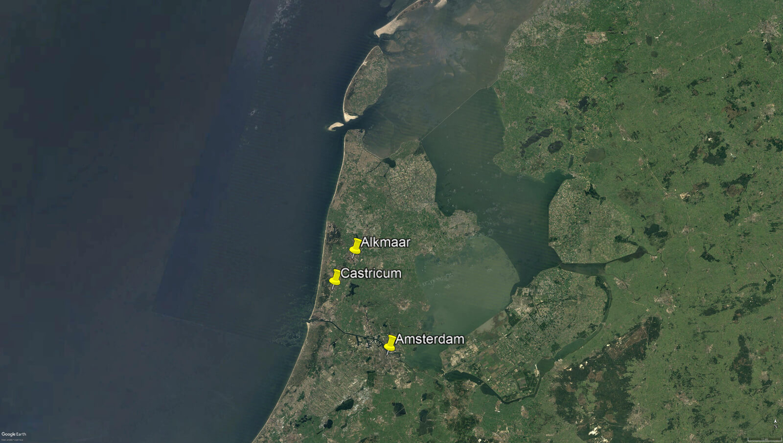
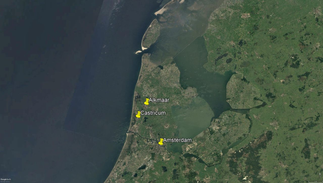
Between 9th to 12th October, I attended this conference, held jointly in the city of Alkmaar and town of Castricum, in North Holland. I’ve been a member of the Internationales Sachsensymposion, an annual gathering of academics who specialise in the study of the first millennium AD in northern Europe, for many years. These gatherings are always interesting and enriching; they provide an opportunity to see landscapes hitherto known only from maps, and meet fellow researchers, putting faces to, and becoming friends with, names that would otherwise be known only from bibliographies. There is usually a strong British contingent present, but this year I was the only English person present, due to the uncertainty over international travel arrangements caused by the pandemic.
This year’s symposium, which had been postponed from last year (again, because of the pandemic), held a great deal of relevance for our ongoing work on the Lossenham Project, and the study of the Rother valley and levels. Like the Rother valley and Romney Marsh, North Holland is an extremely dynamic (and often fluid) landscape, whose geography and history has been dominated over millennia by changes in sea level, climate, and the courses of river systems. Thus, I noted many points of relevance in the presentations. ‘Millennia of coastal dynamics: A new series of palaeo-geographical maps of the province of North Holland’, a paper by Peter Vos and Rob van Eerden, was of particular interest. This showcased a series of new maps, drawing on the latest available evidence, that reconstruct the extremely complex changes in the coastline and islands of North Holland over three millennia, providing snapshots at 500 and 250 BC, and AD 100, 500, 800 and 1250. These maps were the product of thousands of hours of painstaking research and allow us a clear picture of the shifting landscape of this low-lying region over time; they will be of immense use to researchers for decades to come. I hope that in due course our own work on the Lossenham project will allow us to refine the maps we can present of the Rother Valley and its relationship with the marshes and coastline to the east and south-east.
One thing that struck me about the new Dutch maps was that they do not show a simple progression of land reclamation over time. Rather, the picture is much more complex, with areas becoming inundated, or becoming dry, in response to various environmental changes over time. In particular, the map for the thirteenth century showed many newly inundated areas compared to the earlier maps. This was, apparently, due to great storms breaching coastal sand dunes and other defences. This is pretty much what happened in our region from the mid-1200’s onwards, culminating in the total destruction of Old Winchelsea, hitherto one of the most important ports on the south coast, in 1287. It was a clear reminder, if one were needed, that the British coast is only one side of the story, and that what happens on the other side of the Channel, or indeed the North Sea, is inextricably connected to, and part of, Britain’s past. That is what makes international networks such as the Sachsensymposion just as important and valuable as they ever were to understanding our shared European heritage.
Andrew Richardson

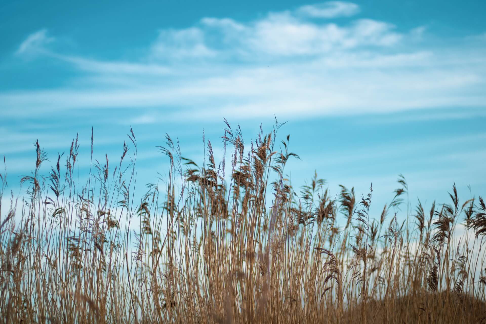
As many of you will know, common reed (Phragmites australis) is a common and widespread species in Britain, and is one of our largest native grass species, growing to 3-4m tall. It occurs naturally throughout the Rother valley, and you will have seen that it is rapidly able to expand its coverage in suitable habitat such as drainage channels and low-lying areas of land.
At Lossenham we were recently very fortunate to receive a visit from Richard Starling, an expert on the subject of reedbed management. Richard has worked as a reed and sedge cutter in the Norfolk Broads for most of his life, managing reedbeds in some of the most important wetland conservation sites in the country. Through carefully tending and harvesting this crop of grass, the reedbeds he manages have been providing thatching materials to the industry for decades.
Richard’s visit and his associated advice has significantly expanded our knowledge of the properties required to create and manage a healthy reedbed for both reed production and for wildlife. Water is not required year-round, and contrary to what I had thought, significant periods of deep water can in fact have an unhealthy impact on the root system. Clean, flowing water is preferable, and shallow inundation in the height of the growing season (Apr-Jun) is key to a successful crop.
Not only have we learnt about reedbed management for the production of thatching reed, but also the prized features of the reed itself - a straightness of stem as well as a thick stem-wall define the quality of the reed for thatching. Early indications from existing reed at Lossenham suggests that we already have reed of good quality (wall thickness) and that ‘straightness’ will be enhanced by rotational cutting. This winter we will cut and store a few bundles of existing reed for local thatchers to come and view and assess, as we wish to invite their interest in our plans for some of the farmland at Lossenham…
Looking ahead, we will be ‘reeding’(!) the lie of the land to assess the most suitable areas on which we can produce reed for thatching, making use of existing drainage channels and low-lying areas to create the right hydrological regime for reed growth. We will trial several areas, ‘seeding’ them with our endemic reed from elsewhere on the farm, and then wait patiently for reed to further colonise before management can be introduced.
And you may well ask “why on earth are you going to have a crack at growing reeds?!”. The reasons are several-fold; all are valid and in combination are somewhat compelling! Firstly, the financial return from reed production (once established) are likely be better than existing use as grazing marsh. Secondly, it represents a productive use of low-lying land in an environment where water levels are challenging. Thirdly, the root system (rhizomes) of reed helps to create soils (peat), raising the level of the land whilst also locking up carbon in the process. And finally, managed reedbeds support a range of wildlife including iconic species such as water vole, otter and bittern.
We wish to trial reed production to assess the merits of this change in farming practice. Whilst we will be doing so under our own steam, it is highly likely that such changes in ‘crop’ in the Rother valley would attract significant positive attention from both the existing and upcoming agri-environment grant schemes. If others have already made the leap and are trialling reed production in the area, we would be delighted to hear from you and hope you will share your experiences.
And remember - this is nothing new! For thousands of years people have harvested materials from the marshes. Unfortunately we have very limited historical information about the harvesting of reed in the Rother valley, and would keenly invite anyone who has any information about past reed cutting (or perhaps sedge cutting) to please get in touch.
Did you know… that an estimated 98% of all thatching reed is imported to the UK, some of it from as far afield as China! And much of what is imported is of inferior quality to that which can be grown locally here.