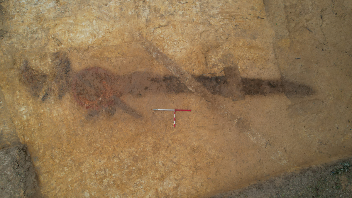
Archaeology at Lossenham has progressed well since the last newsletter, with the Isle Heritage team and project volunteers working hard through the Spring, Summer and early Autumn. At Lossenham Priory, the excavation of the Carmelite church of St Mary continues. The complete footprint of the church is now revealed, a narrow rectangular building measuring approximately 26m by 6m, with buttresses at the corners and along the south wall. Numerous burials have been identified inside the church. One of these contained a lead coffin, which was lifted in early August. This will soon be opened. It is likely to date to the late 1400s or early 1500s, and must contain a wealthy and powerful person, perhaps one of the Lords of Lossenham.
We have also been working at Castle Toll, the large earthwork complex that lies over 1km north-east of the Priory, at the end of the Lossenham ridge. Work here is in its early stages, with a series of small test pits. One area excavation area has been completed. The latter investigated the intersection of a north-south ditch with a trackway that approaches the site along the top of the ridge from the south-west, both features having been picked up on the geophysical survey carried out by the Hastings Area Archaeological Research Group (HAARG). The trackway is flanked by ditches, one of which produced pottery provisionally dated to the Late Iron Age or perhaps early Roman period (circa 100 BC to AD 50).
A third site has now been identified on the farm, in the corner of Guestling Field, about 270m east of the Priory. This is an iron bloomery, comprising a furnace with associated slag-filled gully. The gully was located by the HAARG geophysical survey in 2021, and initially investigated with two trenches that Winter. Recently (September 2023) we excavated this area, and were delighted to locate the actual furnace. The type of slag suggests this bloomery dates to either the Iron Age (about 750 BC to AD 43) or Anglo-Saxon period (about AD 450-1066). Charcoal recovered should enable radiocarbon dating to determine when this bloomery operated. Either an Iron Age or Anglo-Saxon date would represent a very significant discovery, as these are much rarer than equivalent Roman, medieval or post-medieval sites in the Weald. Watch this space, and for regular updates on the archaeological programme at Lossenham visit: facebook.com/isleheritage.
Andrew Richardson
The Lossenham Project is well into its second year now, and a lot of work has been done, and is ongoing, to investigate the historic environment not only of Lossenham itself, but also the wider hinterland of the Rother and its tributary watercourses. We use the term ‘historic environment’ in its widest sense to mean the archaeological and historical records, and the historic landscape. The historic landscape is all aspects of the landscape that has been affected by human activity. Which means most of the landscape as we see it today; little if any is unaffected by human hands. The historic environment of The Lossenham Project is, then, a very big subject indeed, and spans (at the very least) the entire post-glacial period since the last Ice Age, some 10,000 years or so.
There are thus very many ways we could approach this study, many fruitful avenues of research to follow, and many questions we can ask and seek to answer. The truth is, of course, we will never be able to fully explore or question every single aspect of the historic environment of Lossenham, much less of the entire Rother system and its surrounding parishes. We will all pass into the realms of history (and archaeology) ourselves long before that would be possible, not least because in this game any answers you do get have a tendency to generate yet more questions!
Thus, we must focus our efforts. That being said, we intend to do, and are doing a lot; the project has already made significant progress on improving our understanding of the archaeology, history and landscape of this fascinating area. But as the project has matured, it has now become clear that we need to develop and agree a research agenda for it. Research agendas are an integral part of the good management of such research projects. English Heritage (now Historic England) published guidance on this some years ago, known as MoRPHE; ‘Management of Research Projects in the Historic Environment’. In addition, Historic England supported and funded the development of a series of regional research frameworks for England, involving input from a wide range of academics and heritage professionals. The relevant one for us is the South East Research Framework (SERF). This covers the counties of Kent, Sussex and Surrey, and is based around a series of thematic and period-based papers. These can be viewed online at: https://www.kent.gov.uk/leisure-and-community/history-and-heritage/south-east-research-framework
So, we have begun work on a Research Agenda for The Lossenham Project. This is not intended to be a straitjacket (which can be a risk with such things if too rigidly applied) but it is needed to focus our collective efforts on the most promising and interesting research questions within the project area. The draft version directly relates to the themes and periods defined by SERF, which will make it easier to fit our work into the bigger picture of the historic environment of the region. Having said that, I have been struck by how many of the distribution maps of key sites and finds within the SERF resource assessments show little or nothing in the Rother valley area. This underlines the research value of The Lossenham Project; all those of us participating in the project are helping to shed more light on an under-studied and very poorly understood part of south east England. However, it is already apparent that there is much to be found here, and I look forward to working with many of you in the coming months and years to remedy this. At the time-of-writing the Lossenham research agenda remains a work-in-progress. Its creation will be a collaborative process, and indeed it is my intention that many of you reading this will get a chance to contribute your thoughts and questions to it. And in fact, it will never really be finished; it will be a living document that continues to evolve as long as the project continues. So, watch this space!
Andrew Richardson
Making places, making lives: Landscape and settlement in coastal wetlands
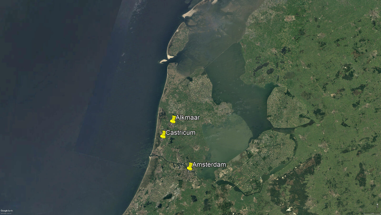
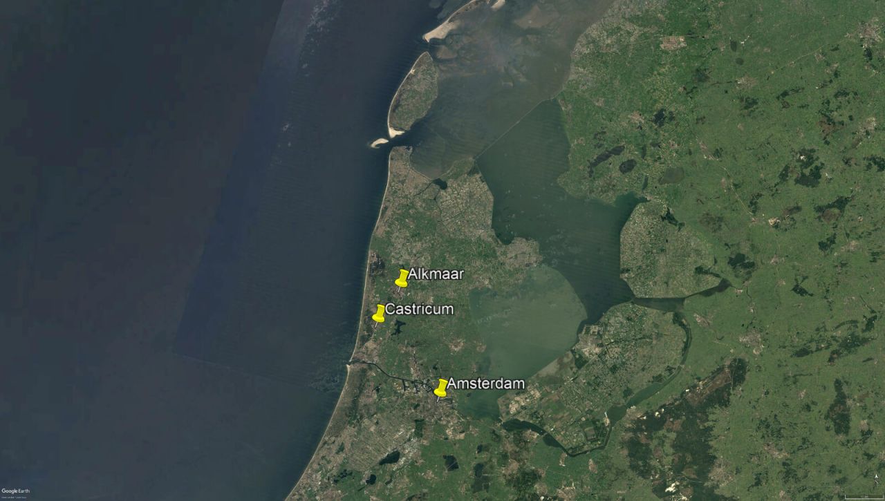
Between 9th to 12th October, I attended this conference, held jointly in the city of Alkmaar and town of Castricum, in North Holland. I’ve been a member of the Internationales Sachsensymposion, an annual gathering of academics who specialise in the study of the first millennium AD in northern Europe, for many years. These gatherings are always interesting and enriching; they provide an opportunity to see landscapes hitherto known only from maps, and meet fellow researchers, putting faces to, and becoming friends with, names that would otherwise be known only from bibliographies. There is usually a strong British contingent present, but this year I was the only English person present, due to the uncertainty over international travel arrangements caused by the pandemic.
This year’s symposium, which had been postponed from last year (again, because of the pandemic), held a great deal of relevance for our ongoing work on the Lossenham Project, and the study of the Rother valley and levels. Like the Rother valley and Romney Marsh, North Holland is an extremely dynamic (and often fluid) landscape, whose geography and history has been dominated over millennia by changes in sea level, climate, and the courses of river systems. Thus, I noted many points of relevance in the presentations. ‘Millennia of coastal dynamics: A new series of palaeo-geographical maps of the province of North Holland’, a paper by Peter Vos and Rob van Eerden, was of particular interest. This showcased a series of new maps, drawing on the latest available evidence, that reconstruct the extremely complex changes in the coastline and islands of North Holland over three millennia, providing snapshots at 500 and 250 BC, and AD 100, 500, 800 and 1250. These maps were the product of thousands of hours of painstaking research and allow us a clear picture of the shifting landscape of this low-lying region over time; they will be of immense use to researchers for decades to come. I hope that in due course our own work on the Lossenham project will allow us to refine the maps we can present of the Rother Valley and its relationship with the marshes and coastline to the east and south-east.
One thing that struck me about the new Dutch maps was that they do not show a simple progression of land reclamation over time. Rather, the picture is much more complex, with areas becoming inundated, or becoming dry, in response to various environmental changes over time. In particular, the map for the thirteenth century showed many newly inundated areas compared to the earlier maps. This was, apparently, due to great storms breaching coastal sand dunes and other defences. This is pretty much what happened in our region from the mid-1200’s onwards, culminating in the total destruction of Old Winchelsea, hitherto one of the most important ports on the south coast, in 1287. It was a clear reminder, if one were needed, that the British coast is only one side of the story, and that what happens on the other side of the Channel, or indeed the North Sea, is inextricably connected to, and part of, Britain’s past. That is what makes international networks such as the Sachsensymposion just as important and valuable as they ever were to understanding our shared European heritage.
Andrew Richardson

This will be only a brief note from me this month, as I’m writing this from my hotel room in Alkmaar, in the Netherlands, and must shortly head out to attend the opening lecture of the 72nd Sachsensymposion, an annual (apart from 2020) gathering of archaeologists and historians who specialise in the study of Northern Europe in the first millennium AD. The theme of this year’s conference, ‘Making places, making lives: Landscape and settlement in coastal wetlands’, promises to chime well with the developing research questions of the Lossenham Project.
Building 1 at Lossenham Friary
Yesterday, Friday 8th October, saw the completion of recording for this year in three of the trenches we had opened on the site of Lossenham Friary. Trenches 2 and 3 have now been backfilled, to protect the fragile building remains that they had exposed. Trench 1, to the south-east, has not been backfilled, but will be provided with a protective cover for the Winter. The plan next Spring is to expand this trench to further expose the building (Building 1) that it had revealed. It now seems likely that this large structure, with thick buttressed walls of sandstone, which runs along the south side of the cloister, is in fact the Priory church of St Mary. It had been suggested that this might have been the refectory, since churches were usually (but not always) positioned to the north of the cloister range. However, the discovery of several graves immediately south of, and parallel to, Building 1, now strongly suggests that this is the church. Its location to the south of the cloister range is probably a result of the local topography; this is by far the most prominent position on the site, overlooking a south facing slope leading down to the Rother. Situating the church here meant there would have been an unobstructed view of it across a wide area, and it seems likely this was the intention. Next year, we aim to reveal much more of this important structure.
Glazed Floor Tiles
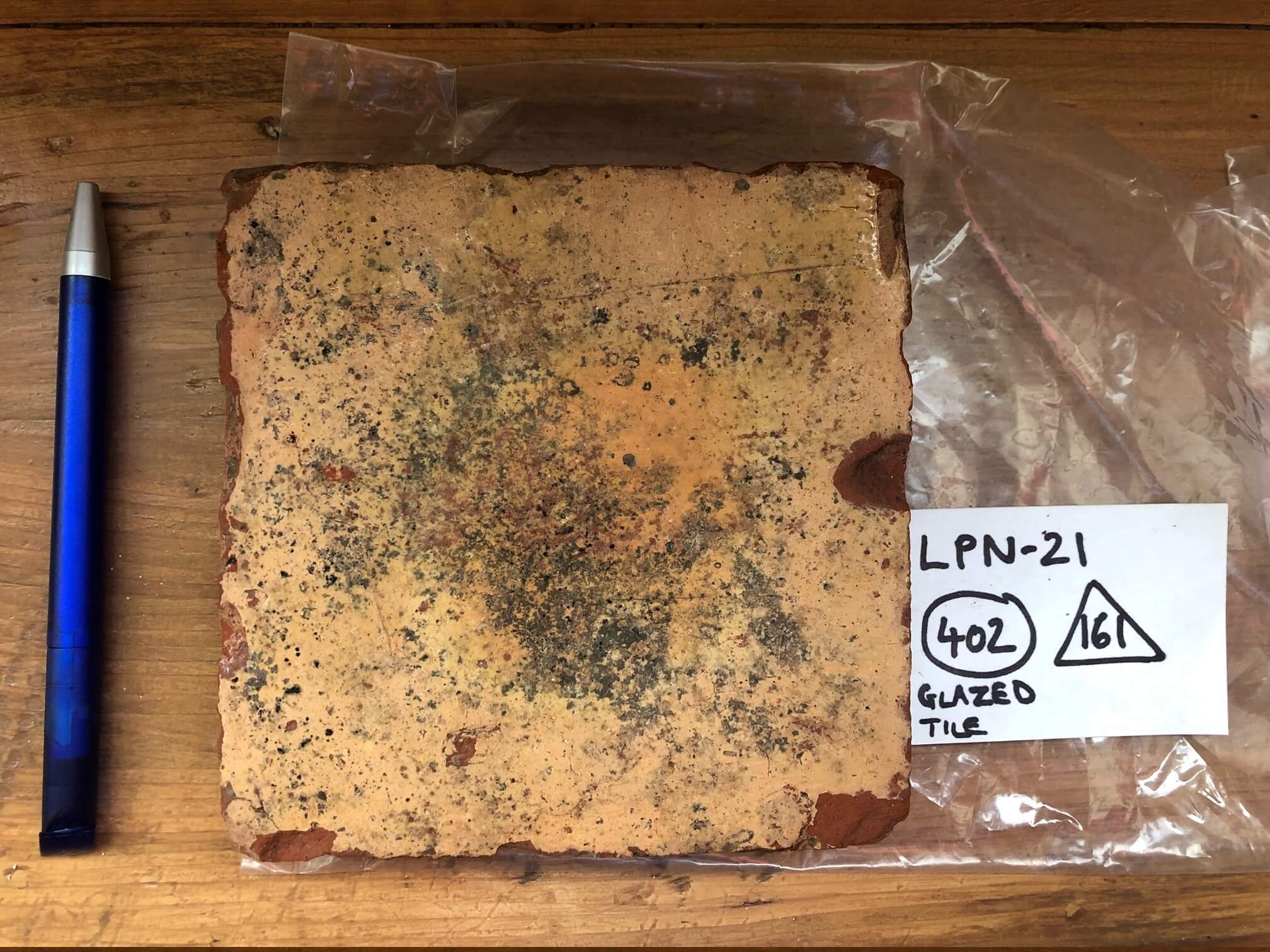
In the last newsletter, I wrote about the glazed floor tiles that we had been finding at the Friary. I noted that although we had several types, all were plain, and that we had not yet discovered any decorated examples. No sooner had last month’s newsletter appeared, than this was out of date, as several fragments of decorated floor tiles were unearthed. All are incomplete, but none seem to match designs known from the Carmelite Friary at Aylesford. Clearly, however, Lossenham was sufficiently wealthy to have been provided with a floor or floors of decorated tiles; we look forward to finding more examples as the excavation of the site progresses.
Andrew Richardson

With just under three weeks of excavation on Lossenham Friary under our belts, we have already amassed a sizeable assemblage of finds. Many of these are still to be washed, and all need to be categorised, sorted, packaged, recorded and then seen by relevant specialists. There is thus lots of work ahead to be done on the finds, a task that will only grow as we excavate more of the site. But this doesn’t stop us taking an informal look at some of the finds, to see what they can tell us about England’s most recently discovered monastic site. I thought we’d start with some of the most evocative finds made so far, the glazed floor tiles.
A diverse range of decorated glazed floor tiles are known from Aylesford friary, founded by the Carmelites in 1242, less than five years before Lossenham. It is believed that most of the tiles at Aylesford came from tile kilns along the Thames. So far, no decorated glazed tiles have been found at Lossenham; all those seen to-date are plain, and none have been found in situ. These might prove to be from kilns nearer to Lossenham, perhaps at Rye, but determining that will be the job of a specialist in medieval ceramic building material (CBM). What we can say is that we now have several complete, and many fragments of, medieval glazed tiles at Lossenham, recovered from all four trenches. The tiles are of several sizes. Most are just over an inch thick (25-30mm). The most common type seems to be tiles with a yellow (or very light brown) glaze, measuring just over 5 inches (127-133mm) square. This type has been recovered from trenches 2 and 4. From trench 4 a very similar, but slightly smaller (4.5 inches, 116-118mm) tile has been recovered, whilst trench 2 produced part of a larger version, measuring just under 6 inches (150mm) square. Multiple fragments of inch thick, yellow-glazed, tiles from all four trenches indicate that these types are found across the site.
A smaller number of tiles have a dark green glaze, which can appear almost black when worn. An example from trench 2 measures 5 inches square, and thus may have been laid in combination with similarly sized yellow tiles to form a chequerboard pattern. A ditch in trench 3, however, produced part of a much larger, green-glazed tile, this measuring at least 8.5 inches by 6.5 inches (minimum 218x166mm), though still being only a little over an inch thick. Fragments of tiles with similar dark green glaze were also found in trench 2, as well as being recovered as general surface finds.
Finally, in trench 1, which has exposed the corner of a large masonry building that may be the refectory, in addition to multiple fragments of yellow-glazed tiles, two fragments of a much thinner tile, just over half an inch thick (15mm) were found. These have a light green glaze and do not appear to have been found anywhere else on the site so far. However, these thinner tiles might be easily mistaken for peg tiles (roof tiles), and more may yet emerge from amongst the finds that are still to be washed. In any case, we can expect more medieval floor tiles to be found as the excavation progresses. If we are lucky some will be found in situ, and some decorated examples may yet turn up. Ultimately, they will have a lot to tell us when reported on by a specialist. For now, it is fascinating to handle them and imagine those who walked across them when they formed the floors of the friary.